This article is about the district in Kerala, India. For its name sake city, see Kottayam. For the old princely state, see Kingdom of Kottayam. For the town in Northern Kerala, see Kottayam-Malabar.
The district is bordered by hills in the east, and the Vembanad Lake and paddy fields of Kuttanad on the west. The area's geographic features include paddy fields, highlands, and hills. As of the 2011 census, 28.6% of the district's residents live in urban areas, and it reports a 97.2% literacy rate.[3] In 2008, the district became the first tobacco-free district in India.[4] Kottayam registered the lowest Multidimensional Poverty Index (MPI) of zero among all districts of India, indicating no deprivation as per the report published by Oxford Poverty and Human Development Initiative and UNDP for districts across India.[5] The district's headquarters are based in the city of Kottayam.
A substantial portion of Kottayam district may have been under the Arabian Sea during prehistoric times. Marine fossils have been found in an area near Changanassery, thus supporting the hypothesis.[6]
However, there are archaeological evidences of the early human inhabitation period of this district, including ancient fossils, stone inscriptions and monuments, in the archeological sites like the excavation sites, the caves, the temples, etc. The literary works of the Sangam period also help to take a look into the ancient period of the district.[6]
Early members of the Chera dynasty (first few centuries of the Common Era) had their original headquarters in a region called Kuzhamur at Kuttanad in the ancient Tamilakam and were sometimes known as the Kuttuvans.[6] The Chera dynasty is mentioned as Keralaputras in the inscriptions of the emperor Ashoka of the Maurya Empire (322 BCE – 184 BCE).[6]
The province Kuttanad of the ancient kingdom of Keralaputras included the modern-day districts of Kottayam, Ernakulam, Idukki, and parts of Alappuzha, which can be defined as the region between the rivers Periyar and Pamba.[6] It was bounded by the Ay kingdom to the south, which included the regions between Pamba River and Kanyakumari (Cape Comorin), and the province of Kudanad, which lies between the rivers Periyar and Chaliyar (modern-day districts of Thrissur, Palakkad, and Malappuram), to the north.[6]
It was during the reign of Uthiyan Cheralathan (105–130 CE) that the Chera dynasty began to expand towards the northern and the eastern regions of Kuttanad by conquering the provinces of Kudanadu and Kongu Nadu.[6] Afterwards the dynasty got split into three branches and fixed their capitals at Muziris, Tyndis, and Caroura, respectively, as seen in the ancient Greco-Roman travelogues as well as the Old Tamil literary works of the Sangam period.[6] During the reign of Narmudi Cheral, the regions included in the Kingdom of Ezhimala was also added to the Chera empire.[6]
Invasions and social transformation from 6th century CE to 800 CE
The ancient Chera empire collapsed due to the continuous invasions carried out by the Kalabhras, the Pallavas, the Chalukyas, the Pandyas, and the Rashtrakutas during the period between 500 CE and 800 CE for nearly three centuries.[6] This era marked the migration of NambudiriBrahmins into the district, which later led to a transformation in the social structure of the region after the 10th century CE.[6] The ancient prominent religions in the district like Buddhism began to vanish after the 10th century CE. Sri Mulavasam was a prominent centre of Buddhism in the Indian peninsula until the early medieval period, prior to the Chera-Chola wars of the 11th century CE.[6]
The regions included in the modern-day district of Kottayam is described well in the medieval Kerala literature which includes works written in both Malayalam and Sanskrit.[6] The 14th century Sanskrit work Sukasandesam describes about Kaduthuruthy.[6] Similarly the 17th century Sanskrit work Bhramara Sandesam contains details about Kumaranalloor and Vaikom.[6] The 18th century Sanskrit literary work Chathaka Sandesam also contains references to Vaikom.[6]
The writings and the records of the Portuguese as well as the Dutch, who visited and interfered in the political affairs of the district after the Age of Discovery (1498 CE), such as the Hortus Malabaricus, contain significant information about the geographical and the political conditions of the region during the late medieval period.[6]
The Chera Perumals of Mahodayapuram (800 – 1102 CE)
Kerala during 11th century CE (the region which is marked as Chera)
The area included in the modern-day district of Kottayam was part of three Nadus (provinces) during the period of the Chera Perumals of Mahodayapuram (800–1102 CE) for nearly three centuries.[6] The region around the city of Kottayam was known as Munjunadu, while the Vaikom-Meenachil region, which lies to the north of Munjunadu was included in a province called Vempolinadu (known as Bimbali Desam in Sanskrit).[6] The third province was the Nantuzhainadu which constitutes the modern-day Taluks of Changanassery and Thiruvalla.[6] This period saw the decline of Buddhism and Jainism, which were once prominent in the region, along with the growth of Hinduism characterised by a large-scale migration of the NambudiriBrahmins into the region.[6]
The territory of the Chera Perumals of Mahodayapuram disintegrated into several small feudal states by early 12th century CE as a result of the continuous war that occurred between the Chera Perumals and the Medieval Cholas throughout the 11th century CE.[6]
The Vazhappally copper plate (c. 882/83 CE[7]) is a copper plate inscription written in Old Malayalam language that dates back to the 9th century CE found at Vazhappally in Kottayam district.[8][9] Recent scholarship puts the date of the plate in c. 882/83 CE.[10] The inscription is engraved on a single copper plate (with five lines on both sides) in an early form of the Old Malayalam language in Vatteluttu script with some Grantha characters. The contents of the plate are incomplete.[8] The inscription was discovered by V. Srinivasa Sastri from Thalamana Illam near Changanassery.[11] The plate is owned by Muvidathu Madom, Thiruvalla.[8] The record is dated to the twelfth regnal year of Chera Perumal king Rama Rajasekhara (882/83 CE).[10]
Inscriptions related to Rama Kulasekhara (1089–1123 CE) of Chera Perumal dynasty can be found at Perunna near Changanassery.[13] The Perunna inscription dates back to the year 1099 CE (the 10th regional year of Rama Kulasekhara).[12]
A political map of the Kingdom of Thekkumkur (1102–1749)
The province Vempolinadu (Bimbali Desam) of the Chera Perumals of Mahodayapuram attained political autonomy in 1102 CE following the Chera-Chola wars of the 11th century CE.[6] The Vempolinadu royal family got evolved into two independent branches by the 12th century CE – the southern branch among them later came to be known as the kingdom of Thekkumkur.[6] It included the modern-day Taluks of Changanassery, Kanjirappally, Kottayam, and Thiruvalla.[6] The kings of the Thekkumkur dynasty are described by the titles Bimbaleeshas and Manikandas in the Sanskrit literary works.[6]Vennimala and Manikandapuram were the early headquarters of the Thekkumkur dynasty.[6] Later it was transferred to Thazhathangady near the town of Kottayam.[6] Thazhathangady is one of the places in Kerala where a church, a mosque, and a Hindu temple co-exist together, which points out the religious harmony that existed under the Thekkumkur Rajas. At times, the town of Changanassery acted as headquarters of the Thekkumkur dynasty.[6]
The Thekkumkur Rajas were vassals to the Kingdom of Cochin until the mid-18th century CE.[6] Thekkumkur Rajas also allied with the Kingdom of Cochin and the Kingdom of Odanad (Kayamkulam) against the military invasions of the kingdom of Travancore into its northern kingdoms that occurred during the 1740s.[6] As a result, Anizham Thirunal Marthanda Varma, the architect of the modern Travancore, attacked and annexed the kingdom of Thekkumkur into Travancore in 1749 during the Battle of Changanassery, after his annexation of Kayamkulam in 1746.[6] The Thekkumkur king took refuge in the kingdom of the Zamorin of Calicut following his defeat in the battle.[6]
Vadakkumkur was the northern branch of the erstwhile province of Vempolinadu which attained political autonomy in 1102 CE after the collapse of the Chera Perumals of Mahodayapuram.[6] The rulers of this dynasty were also known by the titles Bimbaleeshas and Manikandas in the contemporary Sanskrit works just like their Thekkumkur counterparts. The kingdom of Vadakkumkur included the modern-day Taluks of Ettumanoor and Vaikom along with a portion of the Meenachil Taluk.[6]Kaduthuruthy was the earlier headquarters of the Vadakkumkur dynasty which was later transferred into Vaikom.[6] Vadakkumkur was a vassal state of the Kingdom of Cochin until 1750.[6]
The Portuguese explorers described Vadakkumkur as "The Pepper country" due to the availability and high scale production of good quality pepper there during the 16th century CE.[6] The Dutch Malabar who became an influential power in the territory of Vadakkumkur during the 17th century CE and the first half of the 18th century CE had a trade centre at Vechoor (in Vaikomtaluk) in Vadakkumkur.[6] The Kingdom of Kizhmalanadu (1102–1600), which had included the modern-day Taluks of Muvattupuzha and Thodupuzha with its headquarters at Karikode near Thodupuzha, merged with the kingdom of Vadakkumkur around 1600 CE.[6]
Vadakkumkur Raja was also a part of the combined military alliance formed by the kingdoms of Odanad (Kayamkulam), Thekkumkur, and Cochin against the expansion of Travancore into the northern territories.[6] As a result, Anizham Thirunal Marthanda Varma, the architect of the modern Travancore, attacked and annexed Vadakkumkur in 1750.[6] The Vadakkumkur Raja sought asylum in the kingdom of the Zamorin of Calicut.[6] Later he returned back into Travancore.[6]
In 1157 CE, Kulothunga Chola, who belonged to the lineage of the Medieval Cholas, entered into a war with Manavikrama Kulasekhara Perumal, who belonged to the Pandya dynasty of Madurai.[6] Upon the failure in the battle, Manavikrama appointed his brother Maravarman Sreevallabha as the monarch of the Pandya dynasty and left Madurai with his family and some of his trusted servants.[6] Manavikrama crossed the Western Ghats and sought political asylum in Kerala.[6] Manavikrama purchased a vast tract of land bordering the Pandyan territories, from the ruler of Thekkumkur which comprised the Meenachil taluk the regions of Poonjar, Erattupeta, Pala, Patthanamthitta, Thodupuzha, etc. along with the High Range region of modern-day Idukki district in 1160 CE, which originally belonged to the Thekkumkur Rajas.[6] This incident commenced the beginning of the Poonjar dynasty. They were a sovereign state.[6] Though disputed, the territory of Poonjar was claimed by the Kingdom of Travancore in 1899 AD. Travancore claimed that the sovereignty reverted to them following the annexation of the principalities of Thekkumkur and Vadakkumkur in 1749–1750.[6] The land ownership was not disputed.
The Kannan Devan Hills on the High Range region were given on lease on 11 July 1877 by the ruler of the Poonjar dynasty to John Daniel Munroe from London and for tea plantations. The land and the plantations were later resumed by the Government of Kerala through the Kannan Devan Hills (Resumption Of Lands) Act, 1971.[14] However, the act only addressed the issue of sovereignty which was taken over by the State of Kerala with the accession of Travancore to the Union of India. The ownership of the Kannan Devan plantation (125000 acres)leased to John Monroe, and subsequently transferred to Tata Finlay, and finally to Tata Tea was not relinquished by the Poonjar royal family. This was established by a court challenge to the status, which was resolved by a Kerala High Court order in the early 1990s. The order was in favor of the Poonjar royal family establishing ownership. The lease terms are currently being fulfilled with regards to lease payments as per the original deed.[citation needed]
Progress and Social Reformation during the Travancore era (1750–1947)
Entire portion of the modern-day district of Kottayam became part of the erstwhile Britishprincely state of Travancore by 1750 CE. This era marked considerable progress and social reformation in all spheres.[6]
The Church Mission Society press at Kottayam was established in 1821 by Rev. Benjamin Baily, a British missionary, as the first printing press in Kerala.[15] They had also established the CMS College Kottayam in 1815 as the first Western style institute of higher education in India. The region progressed much in its literacy rate by the end of the 19th century CE.[6] It became one of the most literate regions in the British Indian Empire by 1860.[6] Due to its remarkable progress in the fields of literacy, education, and printing, many early newspapers and magazines in Malayalam such as Deepika (1887) and Malayala Manorama (1888) were established in Kottayam.[6]
The same period also saw the commencement of Kerala reformation movement with an aim to eradicate the Untouchability, inequality, and the irrational practices existed in the Kerala society for many centuries which ultimately led to the movements like the Vaikom Satyagraha (1924).[6] Kottayam has been involved in a number of political movements, including the 'Malayali Memorial' movement.[6] The goal of the movement was to seek more representation for Malayalis in the Travancore civil service irrespective of their caste and religion.[16]
Vaikom Satyagraha, a protest against caste discrimination, took place in Kottayam district in 1924.[6] The district also participated in the protests for responsible government in Travancore, which ended with the overthrow of Sir C. P. Ramaswami Iyer, who was the Divan of the British princely state of Travancore in 1947.[6]
The erstwhile Kingdom of Cochin was reorganized into Thrissur district and Taluks of North Paravur and Kunnathunad were transferred to that district.[19] Similarly the Cherthala Taluk was transferred into the newly formed Kollam district on 1 July 1949.[19] The High Range division of the erstwhile Travancore was merged with the remaining Taluks of the erstwhile Kottayam division to form the Kottayam district as a part of the inauguration of the new Indian state of Travancore-Cochin on 1 July 1949.[19] The new district of Kottayam at that time contained eight Taluks – Changanassery, Kottayam, Vaikom, Meenachil, Muvattupuzha, Thodupuzha, Devikulam, and Peerumede.[19]
As a part of the formation of the new Indian state of Kerala according to the States Reorganisation Act, 1956, many jurisdictional changes were done in the district.[20] Two new Taluks, namely Kanjirappally (from Changanassery and Thiruvalla) and Udumbanchola (from Devikulam and Peerumede) were carved out on 1 October 1956.[20] After a month, a new Taluk called Kuttanad was carved out from Changanassery and Ambalappuzha.[20] The Kuttanad Taluk was transferred into the newly formed Alappuzha district on 17 August 1957. The Taluks of Thodupuzha and Muvattupuzha were transferred into the newly formed Ernakulam district on 1 April 1958.[20]
The municipality of Kottayam was declared as the first town in India to achieve 100% literacy in 1989.[22] The Multidimensional Poverty Index prepared by NITI Aayog based on the National Family Health Survey 2015–16 declared Kottayam as the first Indian district to achieve zero multidimensional poverty rate.[22]
There are no distinct seasons in Kottayam, as it has a tropical climate like that of the rest of Kerala. Humidity is high and rises to about 90% during the rainy season. Kottayam gets rain from two monsoon seasons, the south-west monsoon and the north-east monsoon, and accumulates an average rainfall of around 3600 mm per year. The south-west monsoon starts in June and ends in September, and the north-east monsoon season is from October to November. Pre-monsoon rains from March to May are accompanied by thunder and lightning; the highest rainfall during this period in Kerala is received in Kottayam. December, January, and February are cooler, while March, April, and May are warmer. The highest temperature recorded in Kottayam was 38.5 °C on 6 April 1998, and the lowest was 15 °C on 13 December 2000.[23]
The Kottayam district experienced intense red rainfall in 2001, during which the rain was colored red, yellow, green, and black.[24]
Kumarakom, a tourist destination located near the city of Kottayam. It contains the Kumarakom Bird Sanctuary, which is known for migratory birds.[25]
Vembanad Lake is home to traditional cargo boats called Kettuvallams, which are modified into cruise boats and houseboats.[26]Pathiramanal is a small island located in the Vembanad Lake, and is only accessible by boat.[26]
During the Onam festival in August and September, water boat races are conducted in Kottayam. The major one is the Nehru Trophy Boat Race. The Thazhathangadi boat race in Kummanam is over a century old.
Kottayam is linked by major roads and rail to other prominent cities in Kerala, and also by waterways allowing for waterborne travel. The Kottayam Kumali, Ettumanoor-Ernakulam, Kottayam-Pathanamthitta, Thiruvalla-Kidangoor Central Kerala Bypass, and MC road are the major roads in the district. The nearest airport is the Cochin International Airport. SWTD operates ferry services from different parts of the Kottayam district. The ferry service from Vaikom to Thavanakkadavu in the Alappuzha district is the longest. India's first solar ferry service boat, 'Adhithya', operates from Vaikom.[citation needed]
There are three Lok Sabha constituencies in Kottayam district: Kottayam (6 assembly constituencies), Pathanamthitta (2 assembly constituencies, i.e., Kanjirappally and Poonjar) and Mavelikara (1 assembly constituency,
i.e., Changanassery).
Kottayam district is divided into 100 revenue villages for the ease and decentralisation of its revenue administration.[34] They are further incorporated into 5 taluks as eludicated below.[34]
Kottayam has a mountainous terrain as well as low-lying areas very close to sea level. Depending on the location, different varieties of food and cash crops are cultivated. Rice is the principal crop extensively cultivated in low-lying regions like Vaikom and Upper Kuttanad. The district occupies third place in the production of rice in Kerala behind Palakkad and Alappuzha.
Although it is the staple food of the people, the area under cultivation is dwindling due to more lucrative cash crops such as rubber plantations for which Kottayam significantly contributes to the overall rubber production in India. Kottayam is India's largest rubber producer. Rubber trees provide a stable income for farmers and the climate is ideal for rubber plantations. Though the highlands are more suitable, cultivation has spread to almost all regions. Other crops cultivated include tapiocas, coconuts, peppers, and vegetables. To enhance rubber productivity, the government of India has set up a Rubber Board as well as a rubber research institute in Kottayam.[35][36]
The district lacks refineries, ports, and an airport, which are needed for major industries.[citation needed]Aside from two public sector companies, Hindustan Newsprint at Velloor and Travancore Cements at Nattakom, industries in the district consist mostly of small and medium-size operations. These mainly include the publishing and processing of rubber or latex, and manufacturing of rubber-based products.
Confined mostly to the Vaikom area of the district is an industry of coir processing and making coir products.[citation needed] Consisting of more than twenty cooperatives, it employs around 20,000 people.[citation needed] In the hand-loom sector, eight cooperative societies employ 2,100 persons. The district's forests include varieties of softwood and other varieties of timber providing the raw material for several small enterprises in the production of plywood, packing cases, splints, veneers, and furniture.[citation needed]
The first printing press in Kerala, C.M.S. Press, was established in 1821 by Rev. Benjamin Bailey, a British missionary. Malayalam-English and English-Malayalam dictionaries were published in Kottayam in 1846 and 1847. The only cooperative society of writers, authors and publishers (SPCS) for publishing books and periodicals was established in 1945. Kottayam is home to a number of books and periodicals, and is the center of publishing business in the state.[citation needed]
According to the 2011 census Kottayam district has a population of 1,974,551,[38] roughly equal to the nation of Slovenia[39] or the US state of New Mexico.[40] This gives it a ranking of 234th in India (out of a total of 640).[38] The district has a population density of 896 inhabitants per square kilometre (2,320/sq mi).[38] Its population growth rate over the decade 2001–11 was 1.32%.[38] Kottayam has a sex ratio of 1040 females for every 1000 males, and a literacy rate of 97.21%, the highest in the state and 4th highest in India. 28.63% of the population lives in urban areas. Scheduled Castes and Scheduled Tribes make up 7.79% and 1.11% of the population respectively.[38]
Malayalam is the predominant language, spoken by 98.88% of the population. Tamil is spoken by a small minority in urban areas.[41]
According to the 2011 Indian Census, Hinduism (49.81%) is the largest religion in Kottayam, with a significant Christian minority (43.48%). Syro-Malabar, Orthodox, Jacobites and Pentecostals are the main Christian sects. The Muslim population constitutes 6.41% of the district.[42]
The three major religious communities in the Kottayam district are Hinduism, Christianity, and Islam. The Nair Service Society's headquarters are located in the district's town of Perunna, Changanassery. The Mannam memorial, created in memory of social reformer Mannathu Padmanabha Pillai, is also located there.
Thirunakkara Sree Mahadevar Temple – The temple is situated in the heart of Kottayam city and is built in the traditional architectural styles of Kerala. The temple is about 500 years old and was built by the Thekkumkoor Raja, and occupies about 4 acres of land.
Thiruvambady Sreekrishna Swami Temple, Mukkoottuthara - The temple is located near the small town of Mukkoottuthara, 7 km from the historic Erumely on the Pampa route. From here, the distance to Sabarimala is only 40 km.
Vaikom Sree Mahadeva Temple – It is known as the Kasi of the south. The Vaikath Ashtami is held in November and December. Vadakkumpurathupattu is held every 12 years to attract devotees.
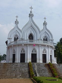
St. Mary's Orthodox Church, KottayamSt. Mary's Orthodox Church, Kottayam —(Kottayam Cheriapalli) (Orthodox) – It was built in 1579 AD with a Kerala and Portuguese style.
^ abcNarayanan, M. G. S. Perumāḷs of Kerala. Thrissur (Kerala): CosmoBooks, 2013. 435.
^Veluthat, Kesavan. "The Temple and the State in Medieval South India." Studies in People's History, vol. 4, no. 1, June 2017, pp. 15–23.
^ ab'Changes in Land Relations during the Decline of the Cera State,' In Kesavan Veluthat and Donald R. Davis Jr. (eds), Irreverent History:- Essays for M.G.S. Narayanan, Primus Books, New Delhi, 2014. 58.
^Rao, T. A. Gopinatha. Travancore Archaeological Series (Volume II, Part II). 8–14.
^ abNarayanan, M. G. S., ed. (2013) [1972]. "Index to Cera Inscriptions". Perumāḷs of Kerala. Thrissur (Kerala): CosmoBooks. pp. 467–70.
^"Archived copy"(PDF). Archived from the original(PDF) on 19 March 2009. Retrieved 11 March 2009.{{cite web}}: CS1 maint: archived copy as title (link) Handbook of Kottayam district, published by Government of Kerala
^ abcdM. K. Devassy (1965), 1961 Census Handbook- Kottayam District, Directorate of Census Operations, Kerala and The Union Territory of Laccadive, Minicoy, and Amindivi Islands
^"Revenue divisions in Kottayam district". National Informatics Centre, Ministry of Electronics and Information Technology, Government of India. Retrieved 13 June 2022.
^ abcde"Taluks in Kottayam district". National Informatics Centre, Ministry of Electronics and Information Technology, Government of India. Retrieved 13 June 2022.
^"റോസ് മേരി". Kerala Women (in Malayalam). Department of Women and Child Development, Kerala state. 26 March 2021. Archived from the original on 24 February 2024. Retrieved 7 April 2022.
M. K. Devassy (1965), 1961 Census Handbook- Kottayam District(PDF), Directorate of Census Operations, Kerala and The Union Territory of Laccadive, Minicoy, and Amindivi Islands


.jpg)


.jpg)

.jpg)
.jpg)


.jpg)


